-
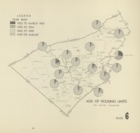 Age of Housing Units
 From Joint Planning Commission (1964) A ComprehensivePlan for Lehigh and Northampton Counties, Pennsylvania; The Lehigh Valley in 1980. p34
-
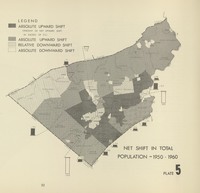 Net Shift in Total Population 1950-1960
 From Joint Planning Commission (1964) A ComprehensivePlan for Lehigh and Northampton Counties, Pennsylvania; The Lehigh Valley in 1980. p32
-
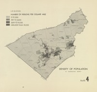 Density of Population
 From Joint Planning Commission, (1964) A ComprehensivePlan for Lehigh and Northampton Counties, Pennsylvania; The Lehigh Valley in 1980. p31
-
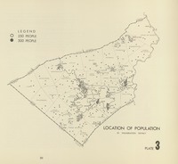 Location of Population
 From Joint Planning Commission (1964) A ComprehensivePlan for Lehigh and Northampton Counties, Pennsylvania; The Lehigh Valley in 1980. p30
-
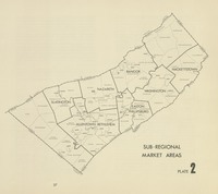 Sub-Regional Market Areas
 From Joint Planning Commission (1964) A ComprehensivePlan for Lehigh and Northampton Counties, Pennsylvania; The Lehigh Valley in 1980. p27
-
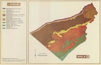 Soils
Soils From Joint Planning Commission (1964) A ComprehensivePlan for Lehigh and Northampton Counties, Pennsylvania; The Lehigh Valley in 1980. p18
-
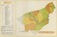 Drainage Areas
 From Joint Planning Commission (1964) A ComprehensivePlan for Lehigh and Northampton Counties, Pennsylvania; The Lehigh Valley in 1980. p17
-
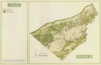 Slope
Slope From Joint Planning Commission (1964) A ComprehensivePlan for Lehigh and Northampton Counties, Pennsylvania; The Lehigh Valley in 1980. p16
-
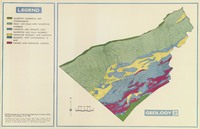 Geology
 From Joint Planning Commission (1964) A ComprehensivePlan for Lehigh and Northampton Counties, Pennsylvania; The Lehigh Valley in 1980. p15
-
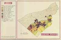 Existing Zoning
 From Joint Planning Commission (1964) A ComprehensivePlan for Lehigh and Northampton Counties, Pennsylvania; The Lehigh Valley in 1980. p9
-
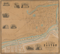
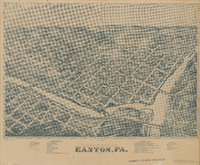 Bird's Eye View of Easton, PA. 1873
 A Bird's Eye View map showing Easton and parts of South Easton and Phillipsburg, NJ, includes reference keys for selected public and commercial buildings
-
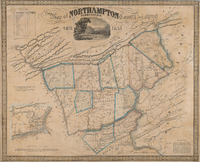 Map of Northampton County Pennsylvania 1851
 Map of Northampton County and surrounding features including the Blue Mountains, parts of Warren County, NJ and the Delaware and Lehigh Water Gaps, large scale inset map of Easton, PA.
-
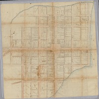 Plan of Easton [1789]
 Cadastral map of the Town of Easton
-
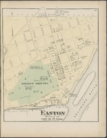
 Plan of the Town of Easton
 Map of the City of Easton and South Easton, Northampton County, Pennsylvania
-
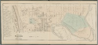
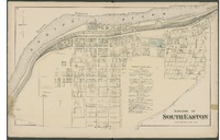 Borough of South Easton
 Map of the Borough of South Easton, Northampton Country, Pennsylvania, Philadelphia:
-
 Plan of Easton Part of 7th Ward
 Map of the City of Easton's 7th Ward, Northampton County, Pennsylvania
-
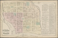
 Plan of Easton Showing the Part of 3rd Ward
 Map of the City of Easton's 3th Ward, Northampton County, Pennsylvania
-
 Plan of Easton Showing the 6th Ward
 Map of the City of Easton's 6th Ward, Northampton County, Pennsylvania
-
 Plan of Easton Showing the 1st, 2nd, 4th, & 5th Wards
 Map of the City of Easton showing the 1st, 2nd, 4th, and 5th Wards, Northampton County, Pennsylvania,
-
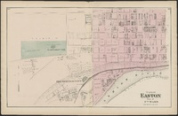
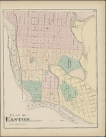 Plan of Easton
 Map of the City of Easton, Northampton County, Pennsylvania
-
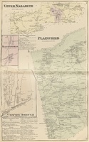 Upper Nazareth, Plainfield, Klecknersville, Chapman Borough
 Four maps showing Upper Nazareth, Plainfield, Klecknersville, and Chapman Borough, Northampton County, Pennsylvania,
-
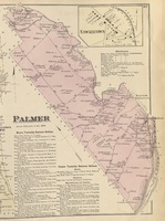 Palmer, Stockertown
 Two Maps showing Palmer Township and Borough of Stockertown, Northampton County, Pennsylvania
-
 Nazareth
 Map of Nazareth, Northampton County, Pennsylvania
-
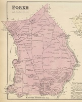 Forks
Forks Map of Forks Township,Northampton County, Pennsylvania
-
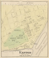 Easton Showing the Part of 3rd Ward
 Map of Easton's 3th Ward, Northampton County, Pennsylvania